Research
Research Interest
Satellite and Remote Sensing Applications in Water Resources and Agriculture, Flood monitoring, Land Cover & Land Use, Climate
Recent Research Projects
Flood impact assessment using open-source Remote sensing data
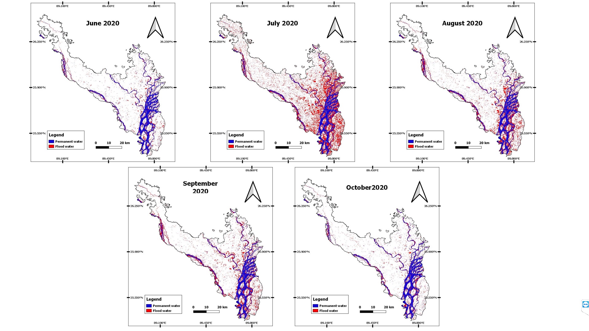
Flood is one of the major natural disasters that cause significant damage to life and property. Mapping near real-time flood inundation is an important input for decision makers to take effective response. Using available active microwave remote sensing data, the operational flood mapping at near real-time can be taken up to support the disaster management authorities. In this study simple method was introduced for flood impact assessment using opensource available data. Using Google Earth Engine Platform inundated areas were calculated from Sentinel 1 by automatic threshold method. For landcover analysis 10-meter resolution Esri 2020 Land Cover map produced by Impact Observatory has been used which is derived from ESA Sentinel-2 imagery and for population exposure analysis 100m resolution population data from WorldPop has been used. The 2020 flood at Kurigram and Lalmonirhat districts of Bangladesh was studied using this method. Flood inundation map were prepared for the months of May, June, July, August, September and October from Sentinel 1 images. Total permanent waterbody was 376 km2 in May which is about 10% of the total study area. Among the months inundation was highest in July, about 698 km2 were inundated which is about 20 % of the study area. About 600000 people were exposed to flood in July, which is about 17% of the total population of the study area. Percentage of inundated cropland was 21.8%, 53.7%, 32.6%, 28.6% and 14% respectively for June, July, August, September and October. About 2% buitup areas were inundated in July which was highest among the months.
2. Flood and water quality monitoring for Dhaka river system
Greater Dhaka is affected by flood, waterlogging and river erosion every year. Many households near Dhaleswari and Upper Turag River are affected by the flood during monsoon in Dhaka and Gazipur. The Turag-Tongi-Balu Rivers are part of a complex peripheral system of rivers surrounding Dhaka. Population increase, release of untreated industrial effluents and sewage, unplanned solid waste dumping along the river banks, encroachment and non‐point source pollution from agricultural activities are major reasons for poor water quality in Turag-Tongi-Balu. Pollution level was high during dry season than wet season but flood during monsoon spreads the pollutants to vast floodplains and imposes threat to health and well-being. So to show the extent of inundation, flood maps were prepared from SAR data(Synthetic-aperture radar) for both dry and wet season. Water Quality Index (WQI) was calculated for the river reaches using the method adopted by the Canadian Council of Ministers of the Environment (CCME).Water quality was found in poor and marginal condition for most of the rivers of greater Dhaka during monsoon 2019. Tongi khal and Balu were in poor condition where lower Turag and Bangshi Savar were in fair condition at that time. During post monsoon of 2019 water quality was improved for most of the rivers. Balu, Buriganga and Turag were in marginal condition at that time.
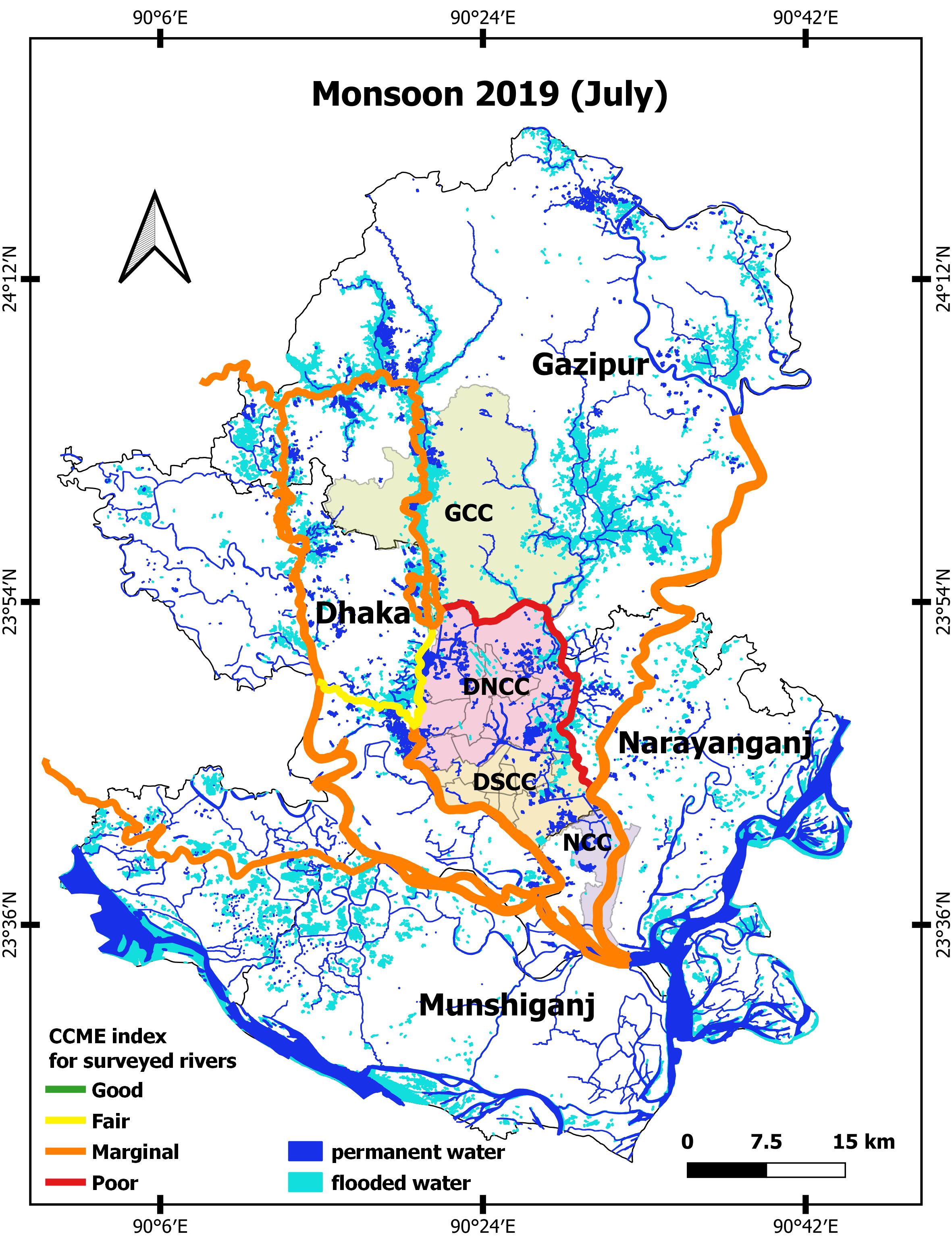
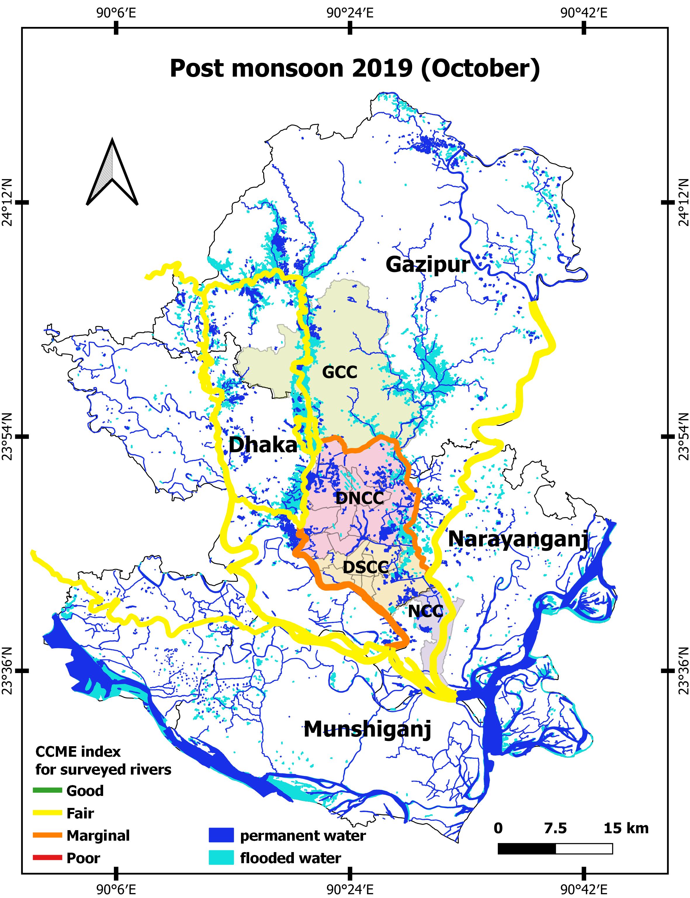
Fig: Water quality index during flood 2019
Several water quality parameters tested don’t meet national water quality standards in both dry and wet season including DO, turbidity, TC and E.coli. Ammonia levels in dry seasons increase more than 2 times than the standard, while it meets the criteria in the wet season. Average turbidity values always exceed the standard (10 NTU) with a high of 70.4 NTU in the wet season and 22.4 NTU in the dry season. For the very low level of DO in the dry season, water is mostly anaerobic thus releasing sulfide and methane gases, causing significant risk on human health.
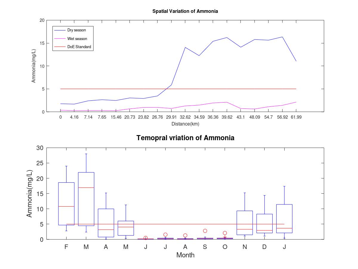
Fig: Ammonia variation in Tongi khal
3. Observing Tidal influence in a river (experimental)
Hydrodynamic model was set up for Dhaleswari River to observe flood inundation and tidal influence at different locations of the river by using HEC-RAS software. Nayarhat and Kalagachia were respectively selected as upstream and downstream for the model. To observe the tidal influences, 10 minutes interval water level data was provided for downstream boundary condition and for upstream boundary condition daily discharge data was used. Tidal range was observed about 0.35 m at upstream (Nayarhat). Near Bhagalpur and Kadamtoli bridge similar pattern of tidal range is noticed. While at downstream (Kalagachia) tidal range was about 0.70 m. Near Baluchar and Dhaleswari bridge tidal range was quite same as Kalagachia.
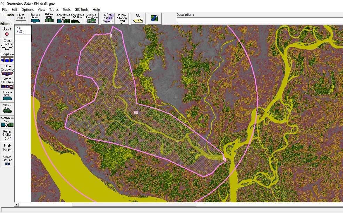
Fig: Model set up in HEC-RAS
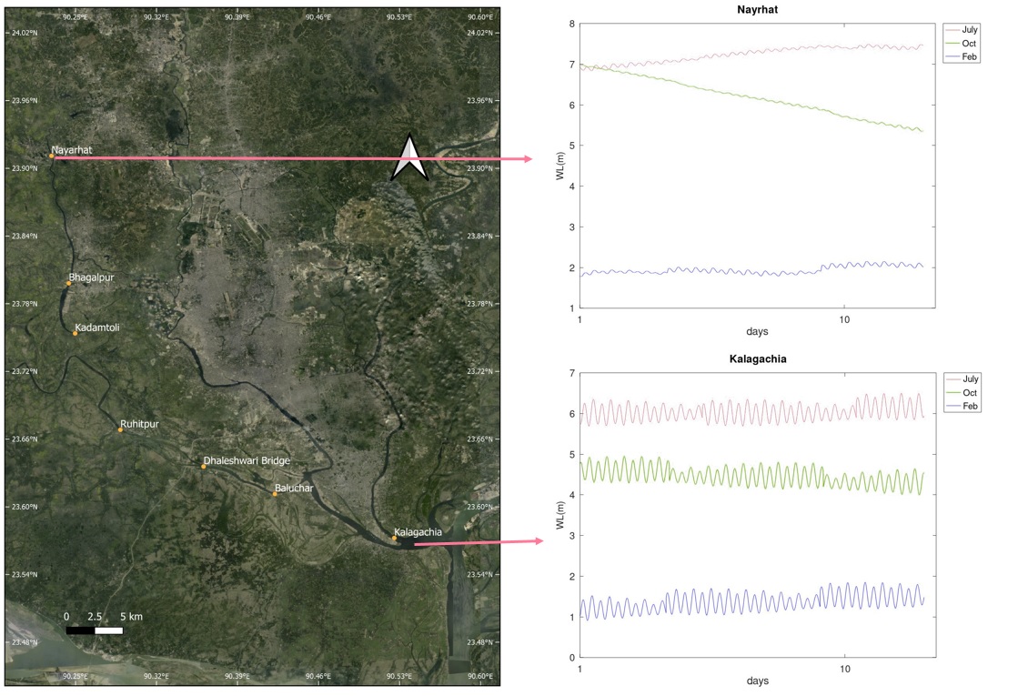
Fig: Water levels at upstream and downstream of the river
Undergraduate thesis
Riverbank migration analysis near the confluence of Ganges-Jamuna by using LANDSAT images
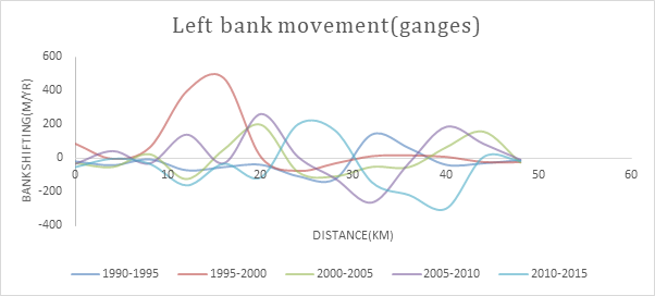
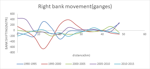
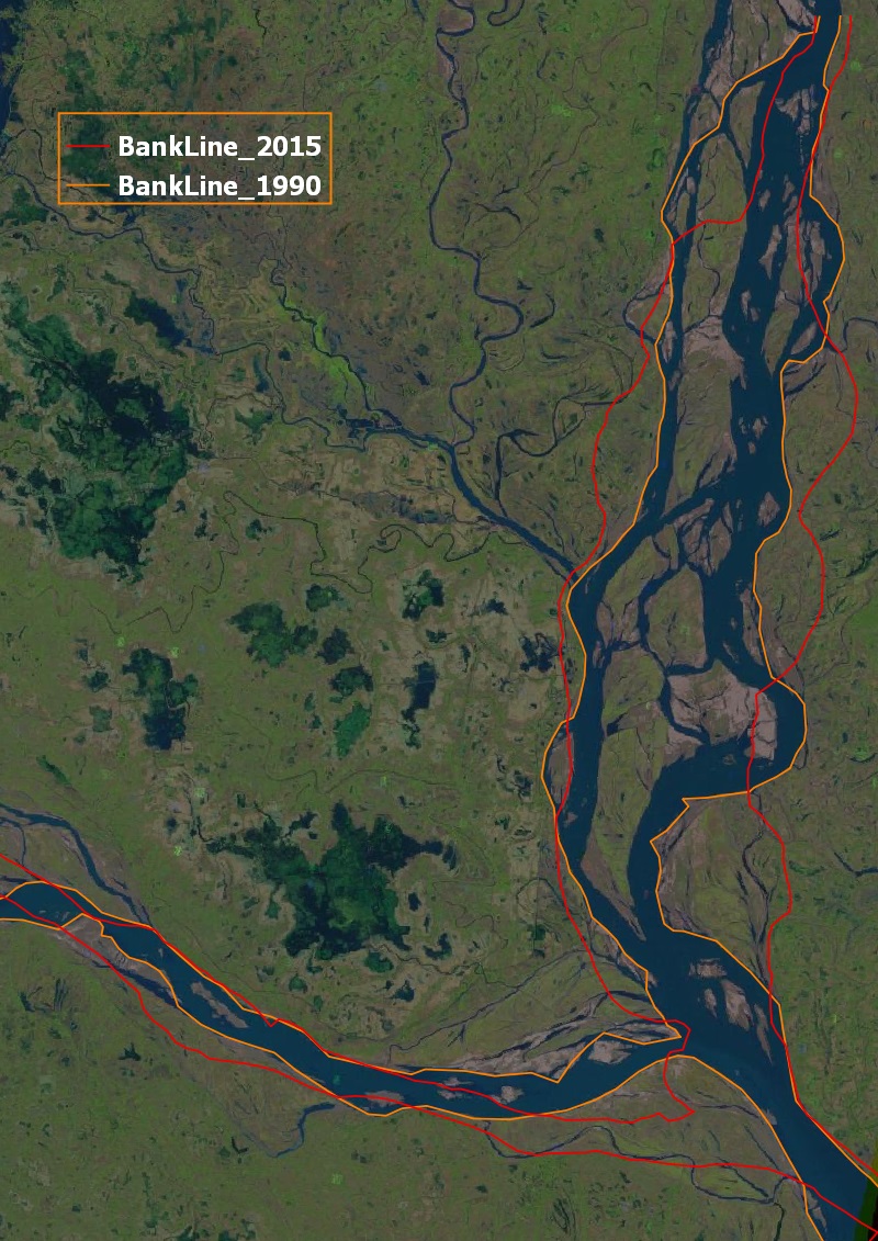
The confluence of Ganges-Jamuna-Padma is one of the most dynamic confluences in the world. Two of the world’s largest rivers Ganges and Brahmaputra meet at this junction causing this point to be of universal importance. Morphological changes in this region has been causing severe erosion along the banks. Riverbank erosion is one of the major challenges faced by Bangladesh as they require very costly intervention. Each year millions of people are affected by riverbank erosion in Bangladesh due to erosion in this confluence zone. So it is very important to understand the pattern of morphological changes in the confluence. This study is aimed at quantifying the actual bank shifting near the confluence of Ganges-Jamuna-Padma for a period of twenty five years (1990-2015) in terms of shifting rate and area. This time span is sub divided into 5 periods with each period having a length of 5 years to evaluate the mature of change. Besides, Long term change from 1972 to 2015 is also qualitatively observed. LANDSAT satellite imagery are used to analyze this morphological change. The purpose of this study is to identify critical bank erosion locations. This study also investigates different morphological parameters of the confluence zone.
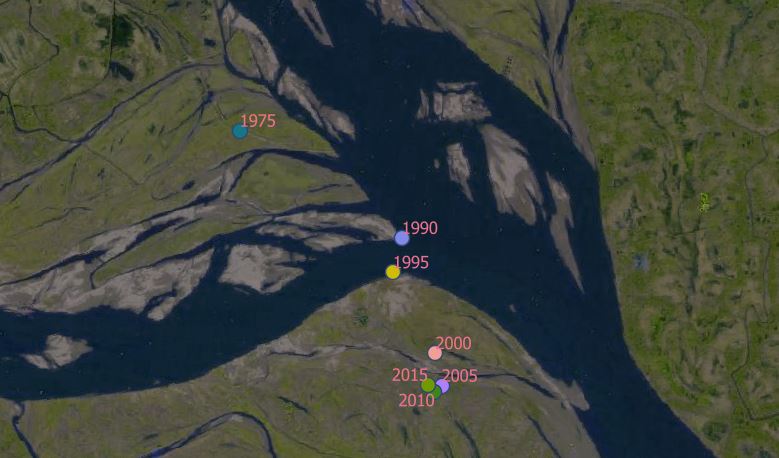
Fig: Confluence point at different years
From analyzing satellite image the largest displacement for both the left bank and right bank of Ganges is observed between 1995 and 2000. For Jamuna maximum shifting for left bank occurred during 1990-1995. On the other hand, for the right bank maximum shifting is observed between 2000 and 2005. For Padma maximum shifting for left bank occurred during 2000-2005. However, for the right bank maximum shifting is observed between 1990 and 1995
